Introduction
The flow of water through well-defined channels is known as ‘drainage’ and the network of such channels is called a ‘drainage system’.
A geometric arrangement of streams in a region is known as a ‘drainage pattern’. In other words, drainage pattern refers to a design which a river and its tributaries form together, from its source to its mouth. The drainage patterns are of various types; Such as – dendritic, radial, centripetal, trellis, Parallel etc.
The drainage pattern of an area is the outcome of :-
- the geographical time period,
- nature and structure of rocks,
- topography,
- slope,
- amount of water flowing,
- the periodicity of the flow,
- tectonic activities and
- the geological history of that region.
Water shed & Drainage basin
A river drains the water collected from a specific area, which is called its ‘catchment area’. The catchments of large rivers are called ‘river basins’ while those of small rivulets and rills are often referred to as ‘watersheds’.
A watershed is an area whose water is carried by a river. Its boundary forms the line that separates the watershed of one river from the watershed of another. The watersheds of large rivers are called river basins, but the catchment areas of small rivers and streams are called watersheds.
However, there is a slight difference between watersheds and river basins. The area of a watershed is usually less than 1,000 hectares. It is also not necessary for watersheds to be formed by small rivers only. Watershed can also be seen without any small water stream. It requires water flow from only one area, which goes into a waterway or lake.
The total area that contributes water to a single drainage system is known as a drainage basin. This is a basic spatial geomorphic unit of a river system, distinguished from a neighbouring basin by ridges and highlands that form divides. Thus, river basins are natural units of land.
The committee on Runoff of the American Geophysical Union treats the micro-units within a river basin as the watershed, while the sum of the micro, meso and macro tributaries of a river is known as river basin.
Synergy and integration are the hallmarks of river basins and watersheds. The incident happening in a basin or watershed has a direct impact on its other parts and the entire unit. Hence it has been accepted as a suitable planning area for planning large/small scale development.
Drainage system of Uttar Pradesh
Parallel drainage pattern is found in the plains of Uttar Pradesh.
Since the north-west part of the state is high and there are sufficient water sources on the Himalayas, most of the state’s rivers flow from north-west to south-east.
On the basis of the places of origin, the rivers of the state are divided into three types, which are as follows-
- Rivers originating from Himalayas; such as – Ganga, Yamuna, Kali (Sharda), Ramganga, Gandak, Saryu (Ghaghra or Karnali), Arij Kosi (tributary of Ramganga), Rohini, Rapti etc. Himalayan rivers are perennial in nature because their source of water is both glaciers and rain. Water remains in these rivers throughout the year.
- Rivers originating from lakes and swamps located in the plains of the state; such as – Gomti, Varuna, Sai, Pando, Isan etc. They are seasonal in nature. These rivers depend on monsoon rainfalls. The water in these rivers reduces considerably in summer, but does not dry up.
- Rivers originating from the plateaus and Vindhya ranges located in the south of the state; such as – Chambal, Sindh, Betwa, Ken, Tons, Kanhar, Rihand, Son etc. They are seasonal in nature. These rivers depend on monsoon rainfalls. These rivers often lack water in summer and mostly dry up.

Important Rivers of UP
Ganga & Yamuna are the largest rivers of the UP. Their flow is determined by the Himalaya in the North and Vindhya Hills in the South.
The Other important rivers of the UP are :
- The Ghaghra,
- The Gomti
- The Rapti
- The Chambal
- The Sind
- The Betwa
- The Ken
- The Son
- The Karamnasha
- The Chandraprabha
- The Rihand
- The Belan
- The Dhasan
The Ganga
The Ganga Basin —
- length 2525 km;
- 110 km in Uttarakhand
- 1,450 km in UP
- 445 km in Bihar
- 520 km in West Bengal
- area 861,404 sq km or 26.3% of the area of India.
The Ganga basin is the most important and the largest river basin in India and the state. It is an international river as it passes through Bangladesh before merging into the Bay of Bengal.
The Ganga is India’s most important and sacred river, which is why it is referred to as “Gangaji” and not just “Ganga”. According to Pt. J.L. Nehru, “From her source to the sea, from old times to new, Ganga is the story of India’s Civilization”.
It was declared a national river on 4 November 2008.
The Ganga originates as Bhagirathi from the Gaumukh (Gangotri Glacier) in the Uttarkashi District of Uttarakhand at an elevation of about 3,900 m. As it progresses, it receives the waters of various rivers such as Rudraganga, Jadganga, Asiganga, Siyaganga, and more. At Ganesh Prayag (East Tehri), it is joined by the Bhilangana River, and at their confluence, the Tehri project is located. At Devprayag, the Bhagirathi meets the Alaknanda; hereafter, it is known as the Ganga.
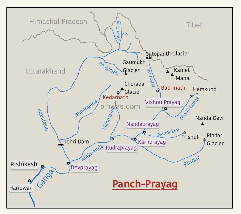
The Alaknanda, originating from the Satopanth Glacier above Badrinath, joins the Bhagirathi at Devprayag. Before making a confluence at Devprayag Alaknanda and its tributaries make five confluences known as Panch Prayag ( five confluences ).
The Alaknanda originates from the glaciers of the Satopanth Glacier and the Satopanth lake in the northern part of Chamoli. Starting with Dhauli Ganga at Vishnu Prayag, followed by Nandakini at Nand Prayag, Pindar river at Karna Prayag, Mandakini river at Rudra Prayag, and finally Alaknanda itself merging into Bhagirathi at Dev Prayag, they together form the Ganga and continue their course.
The five confluences in the upper reaches of the Ganga are:
- Alaknanda and Dhauli Ganga — Vishnu Prayag
- source of Alaknanda river : Satopanth Glacier.
- source of Dhauli Ganga : Mana Glacier.
- Alaknanda and Nandakini — Nand Prayag
- source of Nandakini river : Trishul Glacier.
- Alaknanda and Pindar — Karan Prayag
- source of Pindar river : Pindari Glacier.
- Alaknanda and Mandakini or Kali Ganga — Rudra Prayag
- source of Mandakini river : Chorabari Glacier.
- Alaknanda and Bhagirathi — Dev Prayag
- Source of Bhagirathi river : Gaumukh or Gangotri Glacier.
After the confluence of the Bhagirathi and Alaknanda, the river is known as Ganga. After crossing about 289 km from its source, the Ganga reaches Haridwar debouches from the hills and enters plain area. From Haridwar, it flows in south and south-easterly direction for a distance of 770 km to reach Prayagraj. Here, it is joined by the Yamuna which is its longest and most important tributary.
It crosses another 300 km eastward to reach the plains of Bihar. Near Rajmahal Hills, it turns to the south-east and south of Farakka. Here, it ceases to be known as the Ganga. It bifurcates itself into Hugli in the west and Padma in the east (Bangladesh).
After passing through Kolkata and Haora, the Hugli merges into the Bay of Bengal near Haldia. The Bengal delta is the result of the filling-up of geological sag formed between the Rajmahal Hills and the Chhota nagpur Plateau on the west and the Plateau of Meghalaya in the east. This delta, known as the Sundarban Delta stretches in West Bengal and Bangladesh. The Sundarban Delta is the result of depositional action of the Ganga-Brahmaputra and the Meghna Rivers.
The total length of the river Ganga is 2525 km, out of which 1450 km (57.5%) flows in Uttar Pradesh. In this way, 57.5% of the length of the river Ganges and about 28% of the Ganges basin is in Uttar Pradesh alone.
The Ganga river has a length of 2,525 km. It is shared by Uttarakhand (110 km) and Uttar Pradesh (1,450 km), Bihar (445 km) and West Bengal (520 km). The Ganga basin covers about 8.6 lakh sq. km area in India alone.
The Ganga river system is the largest in India having a number of perennial and non-perennial rivers originating in the Himalayas in the north and the Peninsula in the south, respectively. The Son is its major right bank tributary. The important left bank tributaries are the Ramganga, the Gomati, the Ghaghara, the Gandak, the Kosi and the Mahananda. The river finally discharges itself into the Bay of Bengal near the Sagar Island.
After cutting the Shivalik range, Ganga flows through Rishikesh, Haridwar and then enters Bijnor district of Uttar Pradesh.
As soon as it comes to Plain (Haridwar), its direction starts changing from south to south-east.
From the river Ganga in Uttar Pradesh:
- The main rivers that meet from the left side are Ramganga, Gomti and Ghaghra etc.
- The major rivers that meet from the right side are Yamuna, Tons, Karmanasha etc.
Ganga river flows through 27 districts of the state – Muzaffarnagar, Bijnor, Meerut, Amroha, Hapur, Bulandshahr, Aligarh, Sambhal, Badayun, Kasganj, Farrukhabad, Shahjahanpur, Kannauj, Hardoi, Unnao, Kanpur Dehat, Kanpur Nagar, Pratapgarh, Rae Bareli, Fatehpur, Kaushambi, Prayagraj, Bhadohi, Mirzapur, Chandauli, Varanasi, Ghazipur and Ballia etc.
Ganga is being used as National Waterway (No-1) from Haldia to Prayagraj.
The confluence of the Ganges and other rivers | ||
| Main River | Tributary | Place |
| Bhagirathi | Rudra Ganga | Near Gangotri (Uttarakhand) |
| Bhagirathi | Jadh Ganga | Bairo Ghati (Uttarakhand) |
| Bhagirathi | Assi Ganga | Dodital (Uttarakhand) |
| Bhagirathi | Siya Ganga | Jhala (Uttarakhand) |
| Bhagirathi | Bhilangna | Ganesh Prayag (Uttarakhand) |
| Bhagirathi ( Sas ) | Alaknanda ( Bahu ) | Dev Prayag (Uttarakhand) |
| Ganga | Ramganga | Kannauj (UP) |
| Ganga | Gomti | Kaithi, Ghazipur (UP) |
| Ganga | Yamuna | Prayagraj (UP) |
| Ganga | Tons | Sirsa, Prayagraj (UP) |
Namami Ganga ProgrammeAn integrated conservation mission & ‘flagship programme’ of union government approved in June 2014. Twin object –
Main pillars –
|
The Yamuna
The Yamuna is the westernmost and largest tributary of the Ganges. It originates from the Yamunotri glacier located on the Banderpunch (6,316 m) range. Yamuna joins the Ganga at Prayagraj. Its length is 1,376 km.
Tons, Giri and Asan rivers join it before entering the plain. It enters the state at a place called Faizabad in Saharanpur.
The main rivers that joins Yamuna from the left side are – the Hindan, the Rind, the Sengar, the Varuna, etc.
The main rivers joining the Yamuna from the right are – the Chambal, the Sind, the Betwa, and the Ken.
It flows in the region making the shape of a large arc. It forms the border of Uttar Pradesh with Haryana. It flows through the following 20 districts of the state – Saharanpur, Shamli, Baghpat, Ghaziabad, Gautam Buddha Nagar, Aligarh, Mathura, Agra, Firozabad, Etawah, Jalaun, Auraiya, Kanpur Dehat, Kanpur Nagar, Hamirpur, Banda, Chitrakoot , Fatehpur, Kaushambi and Prayagraj.
The confluence of the Ganges and other rivers | ||
| Main River | Tributary | Place |
| Yamuna | Tons | Uttarakhand |
| ” | Giri | ” |
| ” | Asan | ” |
| ” | Hindon | Near Noida |
| ” | Chambal | Panchnada, Itawah; UP |
| ” | Sind | ” |
| ” | Betwa | Near Hamirpur; UP |
| ” | Ken | Chilla, Banda; UP |
The Ramganga
The mythological name of Ramganga is Rathwahini river. It is also called Western Ramganga River because another river named Ramganga is a tributary of Saryu and has been named as East Ramganga. Yet the name Ramganga has become stereotyped for the western Ramganga river.
It originates from the catchment area of Dudhatoli mountain in Pauri district. It changes its course to the southwest direction after crossing the Shiwalik range. It enters into the plains of UP near Najibabad. It joins the Ganga river in Hardoi district opposite to Kannauj.
The tributaries of Ramganga are – Birma river, Koh ( Khoh ) river etc. The length of Ramganga river is 690 km.
In Uttar Pradesh, the Ramganga River passes through the districts o Bijnor, Moradabad, Bareilly, Badaun, Shahjahanpur, Farrukhabad, Hardoi etc. A dam has been built at Kalagarh for irrigation on this river.
The Sharda ( Kali )
Kali river originates from a place called Kalapani located in Pithoragarh district of Uttarakhand and Gauri Ganga originates from Milam glacier. The confluence of both takes place in Jauljeevi. After Tanakpur it is known as Sharda. It enters the plains near Brahmadev.
It first enters Pilibhit district in the state. It joins the Karnali (Ghaghra river) near Sitapur’s Basra or Baharamghat.
The Ghaghara
The Ghaghara River originates from the Mapchachungo Glacier on the Tibetan Plateau, which is located about 37 km north-west of Taklakot. This river is called Karnali in the mountainous region and Ghaghara in the plain region.
In the plains, this river divides into two sub-branches. Its western branch is called Karnali and eastern branch is called Shikha. Later it becomes one again.
At a place called Sheeshpani, it forms a gorge 180 meters wide and 600 meters deep.
It enters Uttar Pradesh forming the boundary of Lakhimpur and Bahraich districts. Kali river joins near Basra (Baharamghat) in Sitapur.
Ghaghra has many names – Mapcha Tsangpo in Tibet, Karnali in Nepal, Ghaghra in the northern plains of India, Saryu near Ayodhya.
On proceeding from Ayodhya, it is joined by the Rapti river near Barhaj in Deoria.
Then it exits Uttar Pradesh and joins the Ganga near Chhapra. Its total length is 1080 km.
The Rapti
The Rapti River originates near Rukumkot in the south of the Lesser Himalayan Range (Dhaulagiri) in the rear of Nepal. One of its main branches in the northern part is known as Budhi Rapti. Its main tributary is the Rohini, which joins the Rapti on the left at Gorakhpur.
Flowing through Bahraich, Shravasti, Balrampur, Siddharthnagar, Sant Kabir Nagar and Gorakhpur of the state, it joins the Ghaghra river near a place called Barhaj in Deoria. Its total length is 640 km.
The Gomti
Gomti is a terrestrial river. Which originates from Pangaili Fulhar Tal or Gomat Tal located in Pilibhit district. From Pilibhit it flows through the districts of Shahjahanpur, Kheri, Sitapur, Lucknow, Sultanpur and Jaunpur etc. and joins the river Ganges at Kaithi near Ghazipur. The length of Gomti is 940 km.
There is a famous Markandeya Mahadev temple at the confluence of Gomti and Ganga.
Sai is the chief tributary of Gomti, which originates from the Bhijwan lake in Hardoi and joins the Gomti at Rajghat, Jaunpur. Its length is 715 km.
The Gandak
There are two rivers named Gandak. To differentiate between them, one is called Chhoti Gandak and the other is called Badi Gandak. The name Gandak has become a stereotype for Badi Gandak. Apart from this, there is also an old Gandak ( Burhi Gandak ).
Choti Gandak – On the border of Nepal and Uttar Pradesh (Maharajganj), a thin river named Chhoti Gandak emerges from this river, which flows through Maharajganj Kushinagar border, Kushinagar and Deoria and joins Ghaghra east of Salempur.
Badi Gandak / Great Gandak / Gandak – The Shaligrami river that originates from the confluence of the Kaligandaki and Trishul Ganga in Nepal, after moving forward, Narayani is again known as Gandak. Badi Gandak forms the border of Uttar Pradesh and Bihar. Flowing along the border of Maharajganj and Kushinagar with Bihar, this river joins the Ganga near Patna in Bihar.
The Chambal
Chambal river is also known as Charmavati. It originates from Janapao Hills, near Mhow (MP). It forms the border of MP and Rajasthan, MP and UP.
The Chambal River flows through the Agra and Etawah districts from the Uttar Pradesh side and the Morena and Bhind districts from the Madhya Pradesh side. It joins Yamuna at ‘Panch Nadi Sangam’ ( Panchnada ) on the border of Etawah and Auraiya.
Its main tributaries are – Kali Sindh, Kshipra ( Shipra ), Parbati, Banas etc.
It causes a lot of loss of people and money due to sudden floods in the rainy season. Its irregular water flow has created very deep gullies in the nearby areas of the river, which are famous as ravines of Chambal. Its total length is 1050 km.
The Betwa
The ancient name of Betwa is Vetravati. It originates from the south-west of Bhopal in Madhya Pradesh, passes through Bhopal, Gwalior, Lalitpur, Jhansi and Jalaun and joins the Yamuna river near Hamirpur. The total length of this river is 480 km. Many falls are found in its upper part.
The Ken
Cane is also called Karnavati. Its origin is the northern slope of the Kaimur hills. Leaving the Kaimur hills, it enters Banda passing through Bundelkhand and joins the Yamuna river near Chilla or Bhojha in Banda itself. The total length of this river is 308 km.
The Tons
Tons is also known as Tamsa river. It originates from Samsa Kund near Maihar. There are many beautiful water falls on its way, in which Bihar water fall is 110 meters high. There is also a 30 meter high waterfall on its tributary Belan river. It joins the Ganges near Sirsa (Prayagraj). Its total length is 265 km.
The Karmnasha
The Karmanasa River is a river flowing through the Indian states of Bihar and Uttar Pradesh. It is a tributary of the river Ganges. It originates in Kaimur district of Bihar and then it flows and determines the border of Bihar and Uttar Pradesh. On its left (western) side are Sonbhadra, Chandauli and Ghazipur districts of Uttar Pradesh, while on the right (eastern) side are Kaimur and Buxar district of Bihar. The total length of the river is 192 km. It merges with the Ganges near Bara village in Ghazipur district of Uttar Pradesh and Chausa village in Buxar district of Bihar. Its main tributary is Chandraprabha.
The Son
Son is also known as Swarn ( स्वर्ण ) River. It originates from a place called Shoshakund in the Amarkantak hill ( Maikal range ). At first it flows in the north-west and then suddenly turns in the north-east direction. After Madhya Pradesh, it crosses the Sonbhadra district of Uttar Pradesh and joins the Ganga river east of Patna in Bihar. Banas, Gopad, Rihand, Kunhad etc. are its tributaries. It creates many waterfalls in its path. Its length is 780 km.
The Hindon
Hindon is also known as Haranandi ( हरनंदी ) river. This river originates from the foothills of Upper Shivalik and flows for about 400 km between Ganga and Yamuna rivers in Saharanpur, Shamli, Muzaffarnagar, Meerut, Baghpat and Ghaziabad and joins Yamuna near village Momnathal of Gautam Buddha Nagar.
Summary
The drainage system is an integrated system of tributaries and a trunk streams which collect and funnel surface water to the sea, lake or some other body of water.
The river of Uttar Pradesh can be divided into three categories :
- Originating from Himalayas – such as Ganga, Yamuna, Ramganga, Sharda, Ghaghara, Rapti Gandak etc.
- Originating from Plateau region – such as Chambal, Sind, Betwa, Ken, Tons, Son, Rihand etc.
- Originating from Marshy region or Lake – such as Gomti, Sai etc.