Introduction
Physiography ( Physical + Geography ) deals with the surface features and landforms of the earths.
Uttar Pradesh is a border state of India whose border touches Nepal in the north. Before the formation of Uttarakhand, the border of Uttar Pradesh used to touch Tibet of China. After the formation of Uttarakhand, the hilly part of the north came out of Uttar Pradesh and now its border does not touch Tibet.
After the formation of the new state of Uttarakhand, the international border of Uttar Pradesh is only with Nepal. Along with this, the border of Uttar Pradesh meets with 8 states and 1 union territory.
The climate of U.P. is generally of sub-tropical monsoon type, yet climatic differences are found here.
Geographical Location
Uttar Pradesh is a border state located in the north-central part of India.
The latitudinal extent of Uttar Pradesh is between 23°52′ to 31°28′ north latitude. The total latitudinal extent is 7°36′.
The longitudinal extent of Uttar Pradesh is between 77°30′ to 84°39′ east longitude. The total longitudinal extend is 7°09′.
Its length from east to west is 650 km and width from north to south is 240 km. Its total area is 2,40,928 sq km, which is 7.33 percent of the total area of India.
3 states of the country (respectively Rajasthan, Madhya Pradesh and Maharashtra) are more than Uttar Pradesh in area.
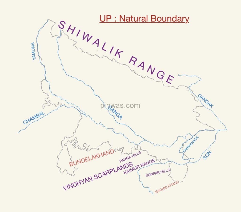
Natural Boundary
The natural boundary of Uttar Pradesh is as follows :
- the Shivalik ranges of the Himalayas to the north of Uttar Pradesh.
- Yamuna river and Vindhya ranges in the west, south-west and south.
- the Karmanasa river in the south-east.
- the Gandak river in the north-east.
Political Boundary
Politically Uttar Pradesh border is as follows :
- International Border with Nepal
- Uttar Pradesh shares border with 8 States & 1 Union Territory, whose names are as follows —
- Uttarakhand
- Himachal Pradesh
- Hariyana
- Delhi ( UT )
- Rajasthan
- Madhya Pradesh
- Chhattisgarh
- Jharkhand
- Bihar
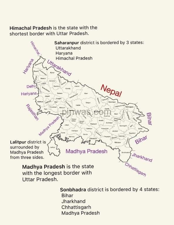
- Borders of Nepal and Uttarakhand in the north;
- Himachal Pradesh borders on the north-west;
- borders Haryana, Delhi and Rajasthan in the west;
- Madhya Pradesh borders to the south;
- The boundaries of Chhattisgarh in the south-east and
- the boundaries of Bihar and Jharkhand in the east touch this state.
Geological Structure
Geologically, Uttar Pradesh is a part of the oldest ‘Gondwana land continent‘ of India. The southern plateau part of the state is actually the north-facing part of peninsular India, which was formed in the Cambrian erafrom the rocks of the Vindhya sequence. There is lack of fossils in the rocks of Vindhya sequence. In this sequence, rocks like limestone, dolomite, sandstone etc. are found. The gneiss rocks formed in pre-Cambrian era are known as ‘Bundelkhand gneiss‘ in Bundelkhand, in which a mixture of minerals like red orthoclase feldspar, red quartz, hornblende chloride etc. is found.
The Gangetic plain lies between the Vindhya range in the south and the Shivalik range in the north. This plain is the result of the deposition of sediments from the Pleistocene epoch to the present day. The layers of alluvium accumulated in this plain are very thick. The ancient alluvial deposits are known as ‘Bangar‘ and the new alluvial deposits are known as ‘Khadar‘. The Gangetic plain is one of the most fertile parts of the world. It has been the cradle of Indian civilization. This has been the basis of the all-India empires of Indian history.
When the rivers enter the Ganga-Yamuna plain from the hills of the Shivalik order, they deposit pebbles and coarse sand in some areas of the beginning. The areas up to which these pebbles and coarse sand are found are called Bhabar area which is in the form of a thin strip. After the Bhabar region, the flat region with fine sediments is called Terai region. Due to excess rainfall in this area, the land becomes marshy. Sugarcane and paddy are cultivated on a large scale here requiring more water.
Physical Division
Before the formation of Uttarakhand state, Uttar Pradesh had three geographical regions – one, the mountainous region of the north, the second, the central plain and the third, the plateau region of the south.
After moving the mountainous region of the north to Uttarakhand, considering the Bhabar-Tarai region adjacent to this mountainous region as a part, the whole region is studied by dividing it into three physical divisions. These are the three physical divisions :—
(1) the Bhabar and Terai region of the north,
(2) the plain region of the middle known as the Gangetic Plain and
(3) the hill-plateau region of the south.
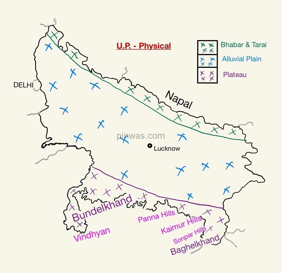
The Bhabar and Tarai Zone
The Bhabar :-
- The northernmost region of Uttar Pradesh is called the Bhabar region.
- To the south of the Shivalik range and to the north of the Terai, the Bhabar region extends in the form of a thin strip.
- The length of this area extends from Saharanpur to Kushinagar (Padrauna).
- The width of the Bhabar strip is about 34 km in the areas around Saharanpur, but the width decreases as it moves towards the east.
- The land of Bhabar region is rough.
- The streams and rivers descending from the Shiwalik at a rapid speed deposit heavy materials of rocks and boulders in the Bhabar tract.
- The porosity is so high that most of the small streams disappear in the Bhabar tract. Only a big rivers are seen flowing over the surface in this tract.
- These disappear rivers reappear in the Terai zone again.
- The Bhabar tract is not suitable for cultivation of crops. Only big trees with large roots thrive in this zone.
The Tarai :-
- Just south of the Bhabar region, a belt of Terai (i.e. Tariwala) region is found.
- It is an area of marshy and silt soil composed of fine sediments.
- This area is flat and moist. Swampy plains are found in this region due to high rainfall.
- From Kushinagar in the east to Saharanpur in the west, there is a continuous decrease in its width.
- The terai region, covered with dense forest and tall elephant grass, was sometimes 80 to 90 km wide.
- It included parts of the districts of Saharanpur, Bijnor, Rampur, Bareilly, Pilibhit, Lakhimpur Kheri, Bahraich, Gonda, Basti, Siddharth Nagar, Gorakhpur, Maharajganj, Deoria and Kushinagar.
- Due to the land reclamation works here, its width has reduced considerably due to which a large part of it has been given to the farmers as fertile land.
- The climate of this region is somewhat less suitable for health. The drinking water here, which is often obtained from wells and shallow pumps, is not up to standard.
- Sal, Haldu, Semal, Sakhu etc. trees and tall grasses are found in this area.
- Due to high rainfall and fertile land, sugarcane and paddy, which require more water, are cultivated in large quantities. Jute is also being cultivated in many places.
- The oldest alluvium found in the high altitude parts of the state is called Rarh.
Except the Bhabar and the south-eastern region, the entire state is made of alluvial soil brought by the rivers.
The Gangetic Plain
The Ganga plain lies to the south of the Bhabar-Terai and to the north of the Bundelkhand and Baghelkhand plateaus.
For convenience, it is divided into three sub-regions –
- Upper Plains ( also known as Upper Ganga-Yamuna Plain )
- Middle Plains and
- Eastern Plains.
Yamuna and Gandak rivers determine the western and eastern boundaries of this vast plain region respectively.
This plain is a very fertile area formed by alluvial soil, mud and sand brought by the Ganges and its tributaries.
The average height of the wide plains of Ganga-Yamuna ranges from 80 to 300 meters above sea level.
The general gradient of the plain is about 15 cm per Km from north-west to south-east. The maximum height of this plain is found to the north of Saharanpur. Some important plain height above sea level ( or elevation ) is as follows :
- Saharanpur – 276 m
- Agra – 169 m
- Kanpur – 125 m
- Prayagraj – 98 m
- Ayodhya – 93 m
- Varanasi – 80.71 m
- Gorakhpur – 75 m
The slope of this plain is from north-west to south-east. The slope of the western part of the plain is steeper than the eastern part.
On the basis of the sediments deposited by the rivers and its structure, this plain can be divided into two sub-parts —
- Bhangar region and
- Khadar region.
Bhangar Region :-
- Bhangar area refers to that area where the flood water of the rivers does not reach and there is accumulation of old alluvial soil.
- Due to being used for agriculture for thousands of years, the fertility of the soil of Bhangar area has decreased considerably.
Khadar Region :-
- Khadar region refers to the alluvium where the rivers keep changing the soil layers every year.
- This soil is very fertile.
- Ravines are also formed due to excessive erosion of cover by rivers in Khadar areas, such as the bank ravines of Yamuna and Chambal. The soil of these ravines is extremely infertile.
The plain of the entire Ganga plain is famous for its fertility. Rabi, Kharif and Zayed crops are cultivated here.
Southern Highlands
The hill-plateau region of the south lies just to the south of the central plain region. This mountainous-plateau region is actually the northern extension of peninsular India i.e. the Deccan plateau, which is known as the plateau of Bundelkhand.
It has Yamuna and Ganga rivers on its northern border and Vindhya mountain ranges on its southern border. The Betwa river flows on its western border.
The slope of this plateau is from south to north.
Lalitpur, Jhansi, Jalaun, Hamirpur, Mahoba, Banda, Chitrakoot, Far southern and south-eastern part of Prayagraj, Mirzapur south of Ganga, some parts of Sonbhadra and Chandauli are included under this area.
Some parts of Baghelkhand are also included in the Bundelkhand Plateau region. In Sonbhadra, the hills of Sonpar and Ramgarh and the area of Son river comes under Baghelkhand.
The average height of this plateau is about 300 meters but some of its hills are up to 600 meters high Like – Sonpar and Kaimur hills of Mirzapur and Sonbhadra.
This plateau is made up of ancient rocks and gneiss rocks. The land is mostly pebbly and desolate. Hills are found in eroded or residual form due to cover erosion.
Chambal, Sind, Betwa, Ken, Tons and Son are the main rivers of this region. Of these, the Chambal, the Sind, the Betwa and the Ken are tributaries of the Yamuna, while the Tons and the Son join the Ganges.
The last river that joins the Ganga in Uttar Pradesh is the Karmanasa, which forms the border with Bihar in the south-east of the state and finally joins the Ganga river at Chausa village in Ghazipur district.
Narrow valleys are found in the plateau region of the rivers. Water sources are found in the mountains and rivers form water falls at many places.
The rainfall is less in the entire plateau region. Due to lack of water and severe heat, the trees are of small size and their development is not complete.
Most of the land in this region is not suitable for agriculture as red soil is found in most parts. Irrigation and potable water are arranged by constructing reservoirs. The main crops grown here are gram, arhar, mustard, jowar and wheat.
The Bundelkhand
It bounded by the Yamuna river in the north, the Vindhyans in the south, the Chambal in the north-west, and Panna-Ajaigarh Range in the south-east.
Bundelkhand is spread over seven districts of Uttar Pradesh and six districts of Madhya Pradesh.
- Lalitpur, Jhansi, Jalaun, Hamirpur, Mahoba, Banda and Chitrakoot – Seven district of UP
- Chhatarpur, Tikamgarh, Damoh, Sagar, Datia and Panna – Six district of MP
The region is characterised by senile topography. The rivers like Betwa, Dhasan and Ken have carved out steep gorges, rapids, cataracts, and waterfalls.
In the western part of Bundelkhand, there is an extension of black soil (regur), which is an extension of the Malwa plateau.
In Bundelkhand, a grass called Chalas is found in abundance.
The Baghelkhand
Baghelkhand is surrounded by the Maikal Range in the south and the Son River in the north. It includes the plateaux of Satna and Rewa ( MP ) and Mirzapur ( UP ). Its elevation varies between 150 to 1200 m with uneven relief. This region is drained by the Son, Karmanasa, Tons rivers.
Conical mounds are found in abundance in the Baghelkhand region. Son river is the main river of Baghelkhand. Sonpur in the north of Baghelkhand and Ramgarh hills in the south are situated.